


Galtee Mountains

mlmoroneybb
Utilisateur
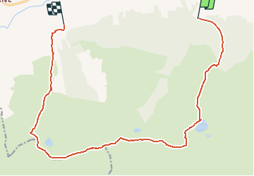

Longueur
15,9 km

Altitude max
911 m

Dénivelé positif
1031 m
Km-Effort
30 km

Altitude min
115 m

Dénivelé négatif
1052 m
Boucle
Non
Date de création :
2014-12-10 00:00:00.0
Dernière modification :
2014-12-10 00:00:00.0
--
Difficulté : Très difficile

Application GPS de randonnée GRATUITE
 SityTrail
IGN / Instituts géographiques
SityTrail Plus
Le monde est à vous
À propos
Randonnée Marche de 15,9 km à découvrir à Inconnu, County Tipperary, The Municipal District of Cahir — Cashel. Cette randonnée est proposée par mlmoroneybb.
Description
5 Lakes view on 6 Mountain peaks in the galtees
Localisation
Pays :
Irlande
Région :
Inconnu
Département/Province :
County Tipperary
Commune :
The Municipal District of Cahir — Cashel
Localité :
Templeneiry
Départ:(Dec)
Départ:(UTM)
559721 ; 5806579 (29U) N.
Commentaires